
Doutchin-Zana Fm
Type Locality and Naming
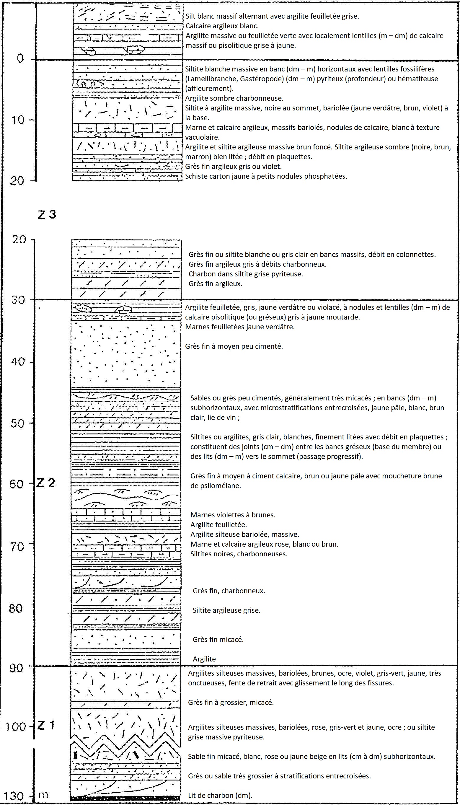
Mount Doutchin Zana, Dakoro region (Fig. 1). Hanon, 1990.
[Figure 1: Typical succession of the Doutchin-Zana Fm was established by the correlation of outcrops and sections of wells drilled near Mount Doutchin Zana (Source: Hanon, 1990)]
References: El-Hamet, 1987; Hanon, 1990; Dikouma, 1990; Moody, 1997; Laouali-Idi et al., 2021.
Synonym: Doutchi-Zana (misspelling); Equivalent(s): Laterally equivalent to the combined Ibeceten Fm (top) and the White Limestone Fm (base) (Fig. 2).
[Figure 2: Lithostratigraphy of the Upper Cretaceous deposits of the Iullemmeden Basin (Source: Modified after Moody, 1997)]

Lithology and Thickness
In the Ader Doutchi region, it is a predominantly pelitic assemblage not outcropping frequently and in which the following facies are found:
- (Most frequent). Dark, brown, gray, and black clays, locally rich in carbonaceous materials; gypsum, septarias, isolated centimetric beds of silts and fine white sands.
- Beige marls, light gray;
- Yellow, beige, grainy limestones, locally pisolithic, in decimetric banks or lenses.
In the Dakoro region, it is a succession of beds or groups of metric beds alternating very varied lithological facies: limestones, marls, clays and often carbonaceous argillites, silts, siltstones and fine to coarse sandstone (Fig. 1). Its thickness is 30 m in the Ader Doutchi region and 130 m in the Dakoro region (Fig. 1).
Relationships and Distribution
Lower contact
Underlying unit is the Iguéllala Mountains Fm
Upper contact
Overlying unit is the Majias Gr / Alanbanya Fm
Regional extent
GeoJSON
Fossils
Plant debris
Age
Depositional setting
Marine to continental
Additional Information